Badger Maps: Map Your Sales Territory
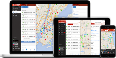
Badger Maps is a route optimization app for sales territories that allows field sales people in any industry to visualize customer information geographically on Google Maps. Color-coded drop pins mark accounts that can be filtered based on user-defined parameters such as revenue, priority, time since last follow up, units sold, or future sales goals. The sales route is optimized automatically, taking into account traffic updates, distance, and location of accounts. You can even throw in stops for coffee, restaurants, or hotels that are located most conveniently on your route.
Generate new leads in the field as you visit neighboring clients, filling in empty time slots as meeting times fluctuate or cancel altogether. You can utilize your schedule efficiently by checking in or approaching a new business opportunity that’s just right around the corner.
Sales managers also love using applications like Badger Maps to reduce time spent on sales training, making the onboarding process a much smoother process.
Currently Badger Maps is the #1 downloaded sales app in the App Store and currently integrates with your customer’s data via a CSV or Excel file, or with Salesforce right-out-of-the-box. Various other customer relationship management (CRM) systems can be integrated customarily, but Badger has plans to soon connect to 20 more CRMs within 2017. Available on mobile for Android and iOS, iPads, and the web with subscription sizes available for individual to enterprise sized accounts. Visit Badger Maps to learn more and try a free 7-day demo, or read their blog to learn how to better manage your sales territory.

Google Earth: Check Out The Terrain

If you’re doing field sales during the winter months or visiting a rural area you’ve never been, a possibly rugged terrain in the winter could spell trouble. You can’t close deals if you’re stuck in the snow or mud after renting the wrong kind of car. And if nothing else, checking out the terrain can help you find a nice nature walk on your way out of town.
Google Earth is straight-forward, turning Google Maps into a view of its true terrain in photos of the earth taken from aerial photography, geographic information systems and satellite imagery. Google Earth allows for multi-point routing capabilities, allowing users to save, store, and then share multiple destinations.
Earth supports Panarmio Pictures, a feature where users can overlay their own photos onto the map and share photos from specific locations so others can explore the area before visiting. Visit Google Earth’s Product Page to see how Earth is available on desktop, web, and mobile.
Dashfly: New Small Business Trip Planner
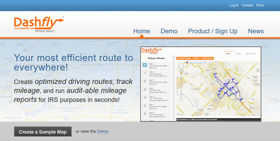
Dashfly is a great tool available across the U.S. for small-fleet route optimization for up to 10 drivers or vehicles. Create a tour for clients or yourself that you can then save, email, or print. Dashfly provides turn-by-turn navigation for up to 25 stops and can import up to 100 routes, where users can then simply re-route by dragging and dropping addresses. Save time, money, and gas while keeping track of mileage. You can also keep a running log in one central location with ready-to-go tax auditable mileage reports. The platform is only available as a web-based application; however, for premium users there is an iPhone app available. It is not as comprehensible as other sales territory applications, but it tends to be more cost-effective. A free 30-day trial found on the Dashfly website makes it a good deal for small freight companies.
Telogis: Sales Territory Mapping for Delivery Services

Telogis is a strategic zone planning platform that is perfect for delivery driving services. Explore their flexible region-planning that systematizes creation of territory zones based on user-defined criteria such as delivery regions, delivery load type and size, driver’s characteristics, and customer requirements. Telogis allows users to test routing scenarios before committing to buying more inventory or hiring, store customer schedules for happier deliveries, and dispatch emergency backup. Checkout more Telogis benefits on the web to start planning a smarter delivery team.
Smartdraw: That's a Beautiful Mapped Sales Territory

SmartDraw allows you to create professional-looking charts and diagrams as a less expensive alternative to Visio. SmartDraw is useful for project management outlines, strategic map planning, undertaking lean initiatives, and mind-mapping out virtual meetings. The platform is available on any browser or mobile device and you can package diagrams in a variety of graphic formats and PDF files to be shared with anyone. Design your sales territory maps in minutes with their multitudes of map templates that you can annotate and color based on your needs. The templates include U.S. and international countries and incorporate map markers, pins, and flag graphics.